Why Fort Lauderdale Construction Projects Need Weekly Drone Progress Photography
Construction in Fort Lauderdale moves fast. Between active commercial development, coastal weather, tight jobsite access, subcontractor scheduling, inspections, owner updates, and lender reporting, project teams need a reliable way to understand what is happening on site without depending only on ground-level photos or verbal updates.
That is where weekly drone progress photography becomes valuable. For owners, developers, general contractors, construction managers, architects, and engineers, consistent aerial documentation provides a clear visual record of progress from the same perspective over time. It helps teams see the full site, verify completed work, communicate with stakeholders, and reduce confusion before small issues become expensive problems.
When businesses search for construction drone photography Fort Lauderdale, they are usually not just looking for attractive aerial images. They are looking for a practical documentation system that supports better decisions, stronger communication, and more transparent project management.
What Weekly Drone Progress Photography Actually Provides
Weekly drone progress photography is not the same as taking a few one-time aerial photos at the beginning or end of a project. The true value comes from consistency. A professional drone operator captures the site on a recurring schedule using planned angles, elevations, and flight paths so each set of images can be compared against the last.
This creates a visual timeline of the project. Over weeks and months, teams can review how sitework, foundations, framing, roofing, exterior finishes, parking areas, landscaping, staging areas, and access routes change. Instead of relying on memory or scattered phone photos, decision-makers have organized documentation that shows exactly how the project evolved.
For Fort Lauderdale projects, this is especially useful because construction sites are often constrained by busy roads, neighboring properties, waterfront conditions, limited laydown areas, and complex logistics. Aerial views reveal relationships across the entire site that are difficult to understand from the ground.
Why Weekly Documentation Matters More Than Occasional Photos
One of the biggest mistakes project teams make is waiting too long between visual updates. Monthly or milestone-only photography may be useful for marketing, but it often misses important changes. In active construction, a lot can happen in seven days. Crews mobilize, trades overlap, materials arrive, temporary conditions change, and work that was visible one week may be covered the next.
Weekly documentation creates a dependable rhythm. It allows the project team to compare progress against the schedule, review sequencing, and identify whether site conditions are aligning with expectations. It also provides a stronger record if questions arise later about when a condition existed or when work appeared complete.
For example, once underground utilities are covered, later verification becomes harder. Once roofing materials are installed, earlier staging and placement are no longer visible. Once exterior finishes begin, prior structural work may be hidden. Weekly aerial images help preserve those moments in the project record.
Key Benefits for Fort Lauderdale Construction Teams
Better Visibility Across the Entire Jobsite
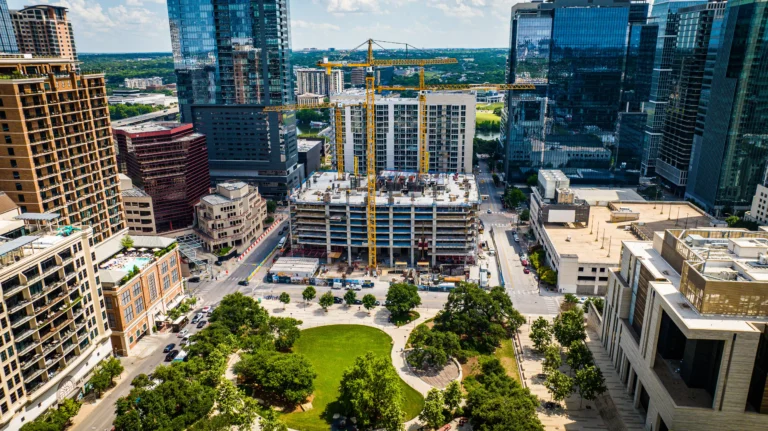
Ground-level photography is important, but it is limited by fences, equipment, materials, and the photographer’s position. Drone photography provides a sitewide perspective. It shows access roads, staging areas, crane locations, material storage, neighboring structures, drainage conditions, parking areas, and the relationship between different work zones.
This wider context is especially helpful for project managers and stakeholders who are not on site every day. A single aerial image can communicate the status of an entire property faster than dozens of disconnected ground photos.
More Effective Owner and Investor Updates
Owners, investors, lenders, and executives often need clear updates without walking the jobsite. Weekly drone progress photography creates professional visuals that make reporting easier to understand. Instead of sending a dense written update alone, the project team can include current aerial imagery that shows visible progress.
This is not just about presentation. Clear documentation builds confidence. When stakeholders can see that work is advancing, site logistics are organized, and milestones are being reached, communication becomes more transparent and productive.
Improved Coordination Between Teams
Construction projects involve many participants. General contractors, subcontractors, architects, engineers, consultants, owners, and property managers may all need to understand current site conditions. Weekly aerial photos create a common visual reference everyone can review.
This can help during coordination meetings, schedule reviews, and problem-solving discussions. Instead of debating what the site looked like, the team can look at the same dated imagery and focus on the decision at hand.
A Stronger Project Record
Documentation matters in construction. When questions come up about sequence, access, material placement, completed work, weather exposure, or site conditions, dated visual records can be extremely useful. Weekly drone images create a chronological archive that supports accountability and helps reconstruct the project history.
While drone photography does not replace formal inspections, surveys, contracts, or field reports, it can complement them by adding a clear visual layer to the project file.
How Drone Photography Helps With Construction Reporting
Professional progress reporting is easier when visuals are consistent. Weekly drone photography can be used in owner reports, lender updates, internal project dashboards, marketing presentations, municipality communications, and executive briefings.
The most useful reports usually combine several perspectives:
- High-angle overview images showing the entire site
- Oblique aerial photos showing building elevations and progress
- Directional views captured from the same location each week
- Close aerial perspectives of major work zones when safe and appropriate
- Before-and-after comparisons at key milestones
These views help translate jobsite activity into clear information. For a busy developer or owner, a well-organized set of weekly aerial images can quickly answer questions such as: What changed since last week? Is the building footprint clear? Are exterior improvements advancing? Are access areas open? Is the site ready for the next phase?
Why Fort Lauderdale Projects Have Unique Documentation Needs
Fort Lauderdale construction comes with local realities that make consistent aerial documentation particularly valuable. Many projects are located near dense commercial corridors, waterfront properties, residential neighborhoods, parking constraints, and active traffic areas. Site access can be limited, and neighboring properties may require careful coordination.
Weather is another factor. South Florida projects must plan around rain, wind, heat, and seasonal storm concerns. Weekly drone progress photography can help document visible site conditions before and after major weather events, show drainage or standing water concerns, and provide a broader view of how the site is functioning.
Airspace and operational planning also matter. Fort Lauderdale has areas where drone operations may require additional attention due to nearby airports, heliports, controlled airspace, people, traffic, and urban density. A professional FAA Part 107 certified drone company understands that construction photography is not simply about flying a drone. It requires planning, safety awareness, regulatory compliance, and coordination with the site team.
What a Professional Weekly Drone Program Should Include
Not all drone progress photography is equal. For construction documentation to be useful, it should be planned and repeatable. A strong weekly program should include a clear scope, defined capture points, consistent scheduling, organized file delivery, and attention to safety.
Consistent Angles and Flight Planning
The best progress comparisons come from photographing the site from similar positions each week. This allows teams to track changes visually without guessing whether differences are caused by actual progress or a different camera angle.
Proper Timing and Site Coordination
Drone flights should be scheduled with awareness of jobsite activity. The operator should coordinate with the contractor or site contact, follow safety expectations, avoid interfering with work, and capture images when lighting and visibility are suitable.
Organized Delivery
Images should be clearly dated and delivered in a format the project team can use. Organized folders, consistent naming, and logical views make the photos easier to reference later. The goal is not only to capture good images, but to make them useful over the life of the project.
Commercial-Grade Image Quality
Construction documentation should be clear, sharp, and properly exposed. High-quality images allow teams to zoom in, review details, and use the photos for both documentation and stakeholder communication. Professional composition also matters when visuals are used in reports and presentations.
Common Mistakes to Avoid
Construction teams sometimes underestimate the importance of planning. Hiring someone to capture random aerial images may produce impressive photos, but it may not create reliable documentation. The most common mistakes include inconsistent angles, irregular scheduling, poor file organization, flights without jobsite coordination, and relying on images that do not show the areas decision-makers care about.
Another mistake is waiting until the project is already well underway. The earlier weekly drone photography begins, the more complete the visual record becomes. Ideally, documentation starts before major sitework, continues through construction, and finishes with final completion imagery.
How to Choose a Construction Drone Photography Provider in Fort Lauderdale
When selecting a provider, look beyond the portfolio. A beautiful aerial photo is valuable, but construction progress documentation requires consistency, reliability, and operational discipline. Ask whether the company has experience with commercial jobsite environments, understands FAA Part 107 requirements, carries appropriate insurance, coordinates with site contacts, and can deliver organized weekly image sets.
It is also important to choose a provider that understands the difference between marketing photography and progress documentation. Marketing images focus on the most attractive view. Progress photography focuses on usefulness, repeatability, and accuracy. The best provider can do both, but the approach must match the purpose.
Frequently Asked Questions
How often should construction drone photography be scheduled?
Weekly photography is a strong standard for active projects because it captures meaningful progress without creating unnecessary volume. Some fast-moving phases may benefit from more frequent documentation, while slower phases may require less, depending on the project needs.
Does drone photography replace site inspections?
No. Drone photography does not replace professional inspections, engineering review, survey work, or required compliance documentation. It supports those processes by providing clear visual records that help teams understand site conditions and progress.
Can drone photos be used in owner reports?
Yes. Weekly aerial images are commonly used in owner updates, lender reports, executive summaries, and project meetings because they make progress easier to understand. Consistent views are especially helpful for comparing week-to-week changes.
Is drone photography allowed near Fort Lauderdale construction sites?
Drone operations are often possible, but they must be planned properly. Depending on the location, airspace, site conditions, and nearby activity, the operator may need to follow specific FAA requirements or obtain authorization before flying. Working with an FAA Part 107 certified provider is important.
When should a project start weekly drone documentation?
The best time to begin is before major visible work starts. Capturing existing conditions, clearing, grading, staging, and early sitework gives the project team a more complete record from start to finish.
Build a Clearer Construction Record With Weekly Aerial Documentation
Weekly drone progress photography gives Fort Lauderdale construction teams a better way to see, document, and communicate project progress. It helps owners stay informed, contractors coordinate more effectively, and stakeholders review the jobsite with greater confidence.
For projects where documentation, transparency, and communication matter, a consistent aerial program is more than a visual upgrade. It is a practical project management tool.
Skyview Motions provides FAA Part 107 certified commercial drone photography and videography for construction projects across South Florida, including Fort Lauderdale. If your team needs reliable weekly construction documentation, professional aerial progress photos can help you keep the project record clear from the first phase to final completion.