New commercial developments are rarely understood from the ground alone. A property may have excellent road frontage, strong access, attractive architecture, carefully planned parking, and proximity to surrounding businesses, but many of those advantages are difficult to communicate in standard ground-level photos. That is where professional drone photography becomes especially valuable.
For developers, general contractors, leasing teams, property owners, and commercial real estate marketers, aerial images help turn a construction site or newly completed property into a clear visual story. They show scale, location, progress, access, and market appeal in a way that is easy for investors, tenants, buyers, and stakeholders to understand quickly.
Commercial development drone photography is not just about getting dramatic overhead images. When planned correctly, it becomes a practical business tool for documentation, marketing, decision-making, and long-term project communication.
Drone Photography Shows the Full Context of a Development
One of the biggest advantages of drone photography is perspective. A ground-level image can show a building entrance or exterior elevation, but it often fails to show how the property fits into its surroundings. For commercial developments, that context matters.
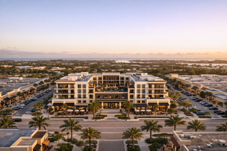
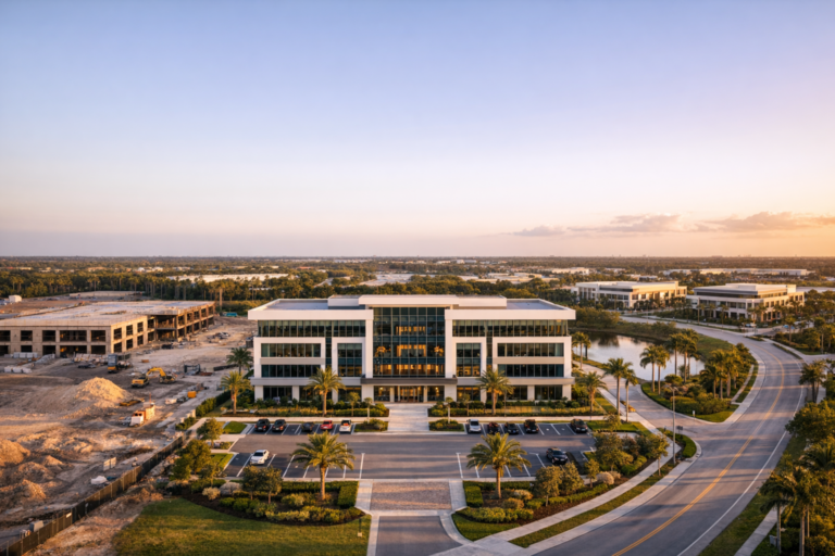
Aerial photography can show nearby intersections, major roads, parking flow, neighboring retail centers, waterfront proximity, industrial access, walkability, surrounding residential density, and visibility from traffic corridors. These details can influence how tenants, buyers, investors, and decision-makers evaluate the property.
For example, a new retail plaza may look attractive from the sidewalk, but a drone image can show how easily drivers can enter the property, how the parking is arranged, and how the development sits in relation to nearby anchor businesses. A new warehouse or flex industrial building may benefit from aerial images that show loading areas, truck circulation, yard space, and access to major routes.
This broader visual context is especially important in South Florida, where location, access, surrounding growth, and land use can play a major role in commercial property value and marketability.
It Helps Stakeholders Understand Progress Faster
Commercial developments involve many people who need to stay informed: owners, investors, lenders, architects, engineers, construction managers, municipalities, leasing teams, and marketing departments. Not everyone can visit the site regularly, and written updates do not always communicate the true status of a project.
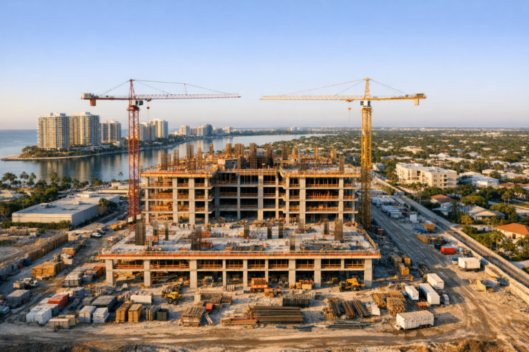
Drone photography gives stakeholders a clear, current view of what is happening on site. From grading and foundation work to vertical construction, paving, landscaping, and final exterior completion, aerial images can make progress easy to understand at a glance.
Consistent photo angles are particularly useful. When a drone photographer captures the same viewpoint over time, teams can compare stages of development without confusion. This can help document milestones, confirm visible progress, support internal reporting, and create a visual record from pre-construction through completion.
Useful stages to document include:
- Pre-construction site conditions
- Clearing, grading, and site preparation
- Foundation and underground utility phases
- Structural framing and vertical construction
- Roofing, facade, and exterior improvements
- Parking lots, access roads, and hardscaping
- Landscaping and final exterior presentation
- Completed property marketing photography
This type of documentation is not a replacement for formal inspections or survey work, but it is a valuable visual reference that can support project communication and recordkeeping.
Aerial Images Strengthen Commercial Real Estate Marketing
Marketing a new commercial development requires more than showing that a building exists. Prospective tenants and buyers want to understand opportunity. They want to see visibility, accessibility, surrounding demand drivers, parking, layout, and the overall quality of the site.
Drone photography can help commercial real estate listings, leasing packages, brochures, websites, presentations, and social media campaigns stand out. It gives marketing teams visuals that are more informative and more engaging than standard exterior photos alone.
For retail properties, aerial photos can highlight storefront orientation, signage opportunities, road frontage, and traffic-facing visibility. For office developments, they can show campus layout, parking convenience, landscaping, and proximity to nearby amenities. For industrial properties, drone imagery can emphasize loading access, building footprint, yard areas, and surrounding logistics infrastructure.
High-quality drone imagery also helps create a sense of credibility. A well-photographed development appears more planned, more substantial, and easier to evaluate. That can be important when presenting a property to tenants, brokers, investors, or ownership groups that need to make decisions before visiting the site in person.
Drone Photography Makes Scale Easier to Understand
Commercial developments often involve large sites, multiple buildings, phased construction, parking fields, stormwater areas, access points, and surrounding infrastructure. These details can be hard to capture from the ground because the viewer only sees one small portion of the site at a time.
Aerial images communicate scale quickly. A single well-composed drone photo can show how a building sits on the parcel, how much parking is available, where entrances are located, and how different site elements relate to each other.
This is useful not only for marketing, but also for planning conversations. Developers and project teams can use current aerial images in meetings to discuss logistics, construction sequencing, tenant improvements, exterior completion, staging areas, and public-facing presentation.
It Supports Better Before-and-After Storytelling
New development is a process. A vacant lot, outdated property, or cleared parcel can eventually become a finished commercial destination. Drone photography is one of the best ways to tell that transformation clearly.
Before-and-after aerial images are especially effective for developers, contractors, and marketing teams because they show the full impact of the work. They can be used in project portfolios, investor updates, case studies, community presentations, and sales materials.
For general contractors, these visuals can help demonstrate construction capability. For developers, they can show vision and execution. For property owners, they can document how capital investment improved the site over time.
Professional Drone Photography Requires More Than Flying a Drone
The quality of commercial development drone photography depends heavily on planning, experience, and operational discipline. A professional drone service should understand both the creative and practical needs of a commercial project.
Important considerations include airspace, weather, lighting, site safety, flight path planning, active construction activity, nearby roads, people on site, and the intended use of the images. The best results come from coordinating the shoot around the project schedule and the visual goals.
For commercial use in the United States, drone operations should be conducted by a remote pilot operating under FAA Part 107 rules. This is important because commercial drone work involves regulatory responsibilities, airspace awareness, and safe operating practices. On construction sites and active commercial properties, coordination with site contacts is also essential to avoid interfering with operations.
What a professional drone photographer should clarify before the flight
- The main purpose of the images, such as marketing, documentation, leasing, or reporting
- The key site features that must be captured
- Whether the property is active, under construction, or complete
- Preferred viewing angles and any required repeat angles
- Best time of day based on sun position and shadows
- Any safety restrictions, access limitations, or site contact requirements
- Final image formats and delivery expectations
This preparation helps ensure the final photos are not only attractive, but also useful for the people who need them.
What Makes a Strong Drone Photo for a New Development?
A strong drone image should do more than look impressive. It should answer a visual question for the viewer. Where is the property? How accessible is it? What is nearby? How large is the site? What stage is the work in? How does the finished development present itself?
Good commercial drone photography typically includes a mix of perspectives. Lower oblique angles can highlight architecture and frontage. Higher angles can show the full site and surrounding context. Straight-down views can be useful for layout, progress, and site documentation, although they are not always the most compelling for marketing.
Lighting also matters. Harsh midday sun can create strong shadows and washed-out surfaces, while early morning or late afternoon light often gives buildings and landscapes more dimension. In South Florida, weather conditions can change quickly, so flexibility and local experience are valuable when scheduling exterior drone photography.
Common Uses for Commercial Development Drone Photography
Different teams use drone images in different ways. A developer may need visuals for investor communication, while a broker may need polished images for leasing. A contractor may need monthly progress photos, while a property manager may need updated images after exterior improvements.
Common uses include:
- Commercial real estate listings and leasing materials
- Investor and ownership updates
- Construction progress reports
- Website and social media marketing
- Broker presentations and offering memorandums
- Project portfolio photography
- Municipal or community presentation materials
- Pre-construction and post-construction documentation
Because the same image set can often serve multiple departments, drone photography can provide value beyond the initial shoot. A well-planned session may produce assets for marketing, reporting, archives, and future presentations.
How to Prepare for a Drone Photography Session
A little preparation can significantly improve the final results. Before scheduling, identify the primary audience for the images. Photos created for a construction update may require different angles than photos prepared for leasing a completed retail center.
It is also helpful to provide a site address, property boundaries if available, a brief description of must-capture features, and any known restrictions. If the site is active, designate a contact who can advise on safe areas, current work zones, and timing considerations.
For completed developments, consider exterior readiness. Clean pavement, completed landscaping, open parking areas, and minimized clutter can improve the visual quality of the shoot. For active construction sites, the goal may be accuracy and documentation rather than a polished marketing look.
FAQ
How often should a commercial development be photographed by drone?
The right schedule depends on the project. Many construction teams benefit from monthly progress photography, while fast-moving phases may require more frequent updates. For marketing a completed development, a single well-planned shoot may be enough, with updates after major tenant buildouts or exterior improvements.
Is drone photography useful before construction starts?
Yes. Pre-construction aerial images can document original site conditions, surrounding context, access points, and nearby development. These images can be useful for planning, stakeholder communication, and before-and-after comparisons.
Can drone photos be used for leasing and sales materials?
Yes. Professional aerial images are commonly used in commercial real estate marketing, including leasing packages, brochures, listing presentations, websites, and digital campaigns. They help prospective tenants and buyers understand the property more quickly.
Do you need an FAA-certified drone pilot for commercial work?
Commercial drone operations in the United States should be conducted by a pilot operating under FAA Part 107 requirements. Hiring a qualified professional helps support safe, compliant, and properly planned drone operations.
What is the best time of day for commercial development drone photography?
It depends on the building orientation, surrounding shadows, and intended use of the images. Early morning and late afternoon often provide attractive light, while some documentation work may be scheduled when visibility across the site is most practical.
Clearer Perspective Leads to Better Decisions
New commercial developments involve major investments, many stakeholders, and a long list of decisions. Professional drone photography helps simplify that complexity by showing the property from a perspective people can understand quickly.
For marketing, it highlights location, access, scale, and visual appeal. For construction teams, it supports progress documentation and communication. For owners and developers, it creates a lasting visual record of the project from the earliest stages through completion.
Skyview Motions provides professional commercial drone photography for developments throughout South Florida, with an emphasis on safe operations, clear communication, and images that serve a real business purpose. If your project needs aerial visuals for marketing, documentation, leasing, or stakeholder updates, a properly planned drone photography session can help you present the development with clarity and confidence.