Construction projects move quickly, and the larger the development, the harder it becomes to keep every stakeholder aligned. Owners want visibility. Lenders want confidence. Project managers need accurate records. Marketing teams need polished visuals. Field teams need documentation they can rely on when questions come up weeks or months later.
That is where professional construction progress photography provides real value. For Palm Beach County developments, aerial and ground-based visual documentation can help capture the full condition of a jobsite at consistent intervals, creating a reliable visual record from site preparation through final completion.
When captured by an experienced FAA Part 107 certified drone team, construction photography Palm Beach County developers use is more than a set of attractive aerial images. It becomes a practical project management, communication, and documentation tool.
Why Construction Progress Photography Matters for Palm Beach County Projects
Palm Beach County has a wide range of active development environments, from coastal commercial properties and luxury residential projects to mixed-use developments, municipal improvements, industrial sites, and large-scale infrastructure work. Each project has different documentation needs, but they all share one challenge: conditions change constantly.
Progress photography helps create a time-stamped visual record of those changes. Instead of relying only on written updates, teams can see what has been completed, what is still in progress, and how the overall site is evolving.
This is especially useful for stakeholders who are not on-site every day. Developers, investors, architects, engineers, property owners, and corporate decision-makers can review current visuals without needing to visit the jobsite in person. For projects spread across multiple locations, consistent photography allows leadership teams to compare progress across sites more efficiently.
What Professional Construction Photography Should Document
Effective construction documentation is not just about flying a drone over a site and taking random photos. The best results come from planning, consistency, and an understanding of what project teams actually need to see.
Site conditions and layout
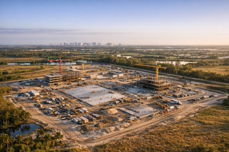
Early-stage imagery can document grading, access roads, staging areas, perimeter fencing, drainage features, neighboring properties, and general site conditions. These images are useful for baseline documentation before major vertical construction begins.
Progress milestones
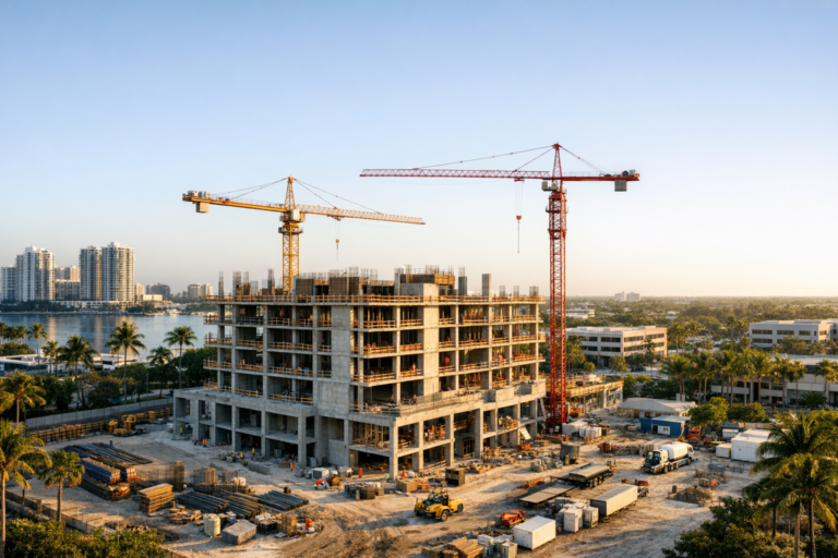
Drone photography can capture key milestones such as foundation work, slab pours, structural framing, roofing, exterior envelope installation, parking lot development, landscaping, and final site completion. Capturing these phases consistently helps build a complete visual timeline.
Material staging and logistics
Aerial views can reveal how materials, equipment, and vehicles are positioned across a jobsite. This can help project managers review site organization and communicate logistics clearly during coordination meetings.
Exterior elevations and surrounding context
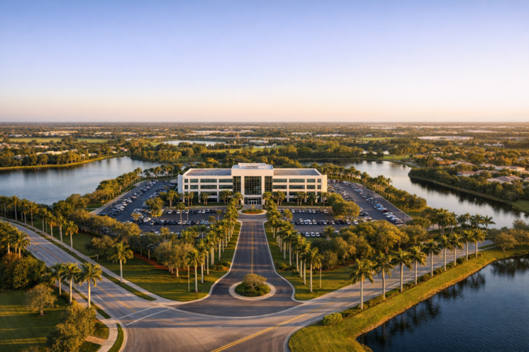
For commercial real estate and development projects, context matters. Aerial imagery can show how a property relates to nearby roads, water features, neighboring buildings, parking areas, and surrounding land use. This is valuable for owner updates, marketing, leasing, and future reference.
The Advantage of Drone Photography for Construction Documentation
Traditional ground photography still has a place on every construction project, but drones provide perspectives that are difficult or impossible to capture from the ground. Aerial imagery can show the entire footprint of a development in one frame, making it easier to understand site progress at a glance.
For larger projects, drone photography can document roof areas, site circulation, drainage patterns, exterior elevations, and overall construction sequencing from consistent vantage points. This broad perspective can help teams identify visual changes that may not be obvious from ground level.
Drone progress photography is particularly useful for developers and contractors who need to communicate with busy stakeholders. A clear aerial photo can often explain more in seconds than a long written update. When paired with ground-level details, it gives a more complete picture of what is happening on-site.
Recommended Photo Schedule for Development Projects
The right photography schedule depends on the size, pace, and complexity of the project. There is no single cadence that fits every development, but most commercial construction projects benefit from a structured plan.
Monthly documentation
Monthly progress photography works well for many projects because it provides a consistent visual record without overwhelming the team with images. This cadence is common for owner updates, lender reporting support, and general project tracking.
Biweekly documentation
Fast-moving projects may require photography every two weeks, especially during phases with visible exterior changes. This schedule can be useful during site work, structural progress, roofing, exterior finishes, and paving.
Milestone-based documentation
Some teams prefer to schedule photography around specific construction events. Examples include pre-construction site conditions, foundation completion, vertical construction, dry-in, exterior completion, substantial completion, and final delivery.
The most effective approach is often a combination of scheduled recurring visits and milestone-based shoots. This creates both consistency and flexibility.
What Separates Professional Results from Basic Jobsite Photos
Anyone can take a photo, but professional construction progress photography requires more than simply capturing images. A qualified drone photography provider should understand safety, airspace requirements, composition, repeatable flight planning, file organization, and the business purpose behind the images.
For example, a project manager may need wide views from the same direction each month to compare development progress. A marketing director may need polished hero images for presentations. A developer may need clear documentation of site status before a funding draw meeting. Each use case requires a different shooting approach.
Professional operators also understand that construction sites are controlled environments with active equipment, workers, deliveries, and changing hazards. Drone operations should be planned carefully, coordinated with the appropriate site contact, and performed in a way that does not interfere with construction activity.
Safety, FAA Compliance, and Site Coordination
Commercial drone operations in the United States must be conducted under FAA rules, and the remote pilot should hold a Part 107 certificate. In areas of Palm Beach County near airports, controlled airspace, temporary restrictions, or sensitive locations, additional planning may be required before a flight can take place.
Professional drone photography also requires jobsite awareness. Before flying, the operator should understand the site boundaries, active work zones, equipment movement, takeoff and landing areas, weather conditions, and any site-specific safety requirements.
Good coordination matters. A short pre-shoot discussion with the project team can clarify the areas to be documented, timing concerns, access limitations, and any operations that should be avoided during the flight. This preparation helps produce better images while respecting the safety and workflow of the jobsite.
How Construction Progress Photos Support Better Communication
Clear visuals can reduce confusion among teams that are working from different locations or reviewing the project from different perspectives. Aerial and ground-level photography can support progress reports, meeting agendas, investor updates, municipal presentations, marketing packages, and internal archives.
For example, a general contractor can use current aerial photos during an owner meeting to show the status of site work and building progress. A developer can include updated imagery in a stakeholder presentation. A commercial real estate team can use polished progress images to build anticipation before leasing or sales efforts begin.
Photos are not a replacement for technical drawings, schedules, inspections, or field reports, but they strengthen those materials by adding visual context. When everyone can see the same current site conditions, conversations tend to become more focused and productive.
Deliverables to Expect from a Construction Photography Provider
Before hiring a provider, it is important to understand what will be delivered and how the files will be organized. A professional construction photography package may include high-resolution aerial photos, selected ground photos, edited image sets, progress galleries, date-based folders, and short aerial video clips when needed.
For recurring projects, consistency is especially important. Images should be delivered in a way that makes it easy to compare one date against another. When possible, repeatable angles and similar flight paths can help create a cleaner visual progression over time.
Ask about turnaround time, image resolution, editing standards, file naming, delivery format, and whether the provider can capture both broad site views and specific requested details. The goal is not just to receive photos, but to receive useful documentation that fits how your team works.
How to Choose a Construction Photography Company in Palm Beach County
When evaluating providers, look for experience with commercial drone operations, not just general photography. Construction sites require a different level of planning than lifestyle shoots or simple real estate images.
A strong provider should be able to explain how they plan safe drone flights, coordinate with site contacts, maintain consistent documentation, and deliver images that support business decisions. They should also understand the importance of reliability. If your project requires monthly documentation, missed visits or inconsistent angles can weaken the value of the visual record.
It is also worth reviewing whether the company understands commercial uses beyond documentation. The same shoot may support project management, owner communication, public relations, leasing, and marketing when captured thoughtfully.
Why Local Knowledge Matters in South Florida
Palm Beach County presents unique working conditions. Weather can shift quickly, afternoon storms are common during certain seasons, coastal light can be intense, and airspace considerations may vary by location. A local drone team understands the practical realities of scheduling, lighting, and site access in South Florida.
Local familiarity can also improve efficiency. Knowing how to plan around morning light, avoid harsh glare when possible, and coordinate around active commercial areas can make a noticeable difference in image quality and workflow.
Frequently Asked Questions
How often should a construction site be photographed?
Many commercial projects benefit from monthly photography, while faster-moving or high-visibility projects may need biweekly documentation. Key milestones should also be photographed when they are important to the project record.
Can drone photos replace site inspections?
No. Drone photos are useful for visual documentation and communication, but they do not replace required inspections, engineering reviews, or professional evaluations. They are best used as a supporting record alongside formal project documentation.
Do you need FAA authorization for every drone flight?
Not always. Requirements depend on the location and airspace. Commercial drone pilots must follow FAA regulations, and flights in controlled airspace may require authorization before operating.
What is the best time of day for construction photography?
Morning often works well in South Florida because the light is cleaner, winds may be calmer, and jobsites are easier to coordinate before the day becomes busier. The best timing depends on the site orientation and project goals.
What should we prepare before a drone photography visit?
Provide the site address, preferred areas to capture, safety requirements, site contact information, access instructions, and any timing limitations. If there are specific progress items the team needs documented, share those before the shoot.
Building a Stronger Visual Record of Your Development
Professional construction progress photography gives Palm Beach County developers, contractors, and project stakeholders a clearer way to understand and communicate jobsite progress. When captured consistently, these images become a valuable record that supports decision-making, reporting, marketing, and long-term documentation.
Skyview Motions provides FAA Part 107 certified commercial drone photography and videography for construction projects throughout South Florida. For teams that need reliable progress documentation, polished aerial imagery, and a professional approach to jobsite coordination, construction photography can become one of the most useful tools in the project communication process.
If your development would benefit from consistent aerial progress documentation, Skyview Motions can help plan a construction photography schedule that fits your site, timeline, and business goals.