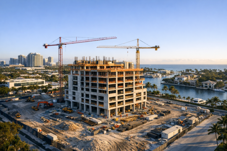
Construction sites are busy, layered environments. From ground level, even experienced project teams can only see one piece of the work at a time: a slab pour, a staging area, a roof section, an access road, or a crew working in a specific zone. Aerial imagery changes that perspective completely.
Professional construction aerial drone services give owners, developers, contractors, architects, engineers, and project managers a clearer way to understand how a site is progressing as a whole. Instead of relying only on walk-through photos or written updates, aerial documentation shows relationships between site features: where materials are stored, how equipment is moving, whether access routes are clear, and how finished work lines up with the surrounding property.
The value is not simply that drone photos look impressive. The real value is that aerial imagery can reveal construction conditions that are difficult, time-consuming, or impossible to understand from the ground. Below are five construction site features that often look completely different from the air, and why that perspective matters for better project communication and documentation.
1. Site Layout and Overall Project Organization
At ground level, a construction site can feel like a maze of fencing, equipment, temporary roads, stored materials, and active work zones. From the air, the organization of the entire site becomes much easier to evaluate.
Aerial drone photography shows how the project is arranged in relation to the property boundaries, neighboring buildings, parking areas, roadways, and access points. This is especially useful on commercial developments, multifamily projects, industrial sites, retail centers, and large renovations where multiple trades may be working in separate zones at the same time.
What aerial images can reveal
- Whether temporary roads and access paths are practical and unobstructed
- How staging areas relate to active construction zones
- Where equipment is positioned across the site
- How work areas are separated from public or occupied areas
- Whether the overall site layout supports efficient movement
For project stakeholders who are not on site every day, this broad view is often the missing piece. A superintendent may understand the site intuitively because they walk it constantly. An owner, lender, architect, or executive team member may not. Aerial documentation helps everyone see the same project conditions without needing to interpret dozens of disconnected ground-level photos.
2. Earthwork, Grading, and Drainage Patterns
Earthwork is one of the clearest examples of a construction feature that looks different from above. From the ground, grading changes can be subtle. Slopes, swales, stockpiles, retention areas, and low spots are often hard to read unless someone is standing in exactly the right location.
From the air, changes in elevation and drainage design become easier to understand visually. While drone photography is not a substitute for survey work or engineering measurements, it is extremely useful for documenting visible site conditions over time.
Why this matters on South Florida projects
In South Florida, drainage, stormwater management, and site preparation are major concerns because of heavy rain, flat terrain, high groundwater conditions in some areas, and the need to manage water movement carefully. Aerial images can help teams visually monitor how grading work is progressing and how water appears to move or collect after weather events.
Drone imagery can also document retention areas, drainage structures, road base preparation, and the transition from rough grading to more finished site work. When captured consistently from similar angles and elevations, these images create a useful visual timeline that supports progress meetings and project records.
3. Structural Progress and Building Footprint
A building can look far more complete from one side of the site than it actually is. Ground photos may show finished exterior panels, installed windows, or active crews in one area, while other sections remain incomplete. Aerial photography provides a more balanced view of the structure as a whole.
From above, teams can see the full building footprint, roof sections, framing progress, slab areas, vertical elements, and how different parts of the structure connect. This is particularly helpful for larger commercial buildings, warehouses, office developments, healthcare facilities, hospitality projects, and mixed-use properties.
Common details visible from the air
- Roofing progress and areas awaiting completion
- Mechanical units or rooftop penetrations that are visible from above
- Structural sequencing across different wings or phases
- Open areas, courtyards, drive lanes, and service zones
- Relationship between the building footprint and surrounding site work
Aerial construction progress photography can also help marketing and executive teams communicate milestones more clearly. Instead of showing a narrow view of one wall or work area, a single aerial image can show the full scale of the structure and how the project is advancing across the property.
4. Material Staging, Equipment Placement, and Site Logistics
Logistics are one of the most important parts of construction management, yet they are also among the hardest to communicate with ground photos alone. A pile of materials may look organized from one angle and obstructive from another. Equipment may seem properly positioned until the full path of travel is seen from above.
Aerial imagery helps teams evaluate whether materials, dumpsters, trailers, cranes, lifts, and vehicles are arranged in a way that supports the work rather than slowing it down. This does not replace the judgment of the site team, but it gives decision-makers a more complete visual reference.
Practical uses for logistics documentation
- Reviewing whether laydown areas are being used efficiently
- Documenting crane or lift placement in relation to the structure
- Monitoring vehicle access and delivery routes
- Identifying congested areas that may affect workflow
- Showing remote stakeholders why certain site decisions were made
For fast-moving projects, regular drone flights can make these changes easier to track. Weekly, biweekly, or milestone-based aerial documentation gives teams a visual record of how the site evolved, where materials were located, and how logistics changed as construction advanced.
5. Surrounding Context, Access, and Neighboring Conditions
A construction project does not exist in isolation. It affects and is affected by surrounding roads, adjacent properties, parking areas, landscaping, utilities, pedestrian paths, and nearby businesses or residences. From the ground, it can be difficult to capture the full context in one view.
Aerial drone imagery shows how the construction site fits into the surrounding environment. This is valuable for commercial real estate teams, developers, property managers, and contractors who need to communicate the bigger picture.
For example, an aerial image can show how a new retail building relates to a main road, how parking areas are taking shape, how close work is to occupied buildings, or how a development is positioned within a larger commercial corridor. For owners and marketing teams, that context is often just as important as the construction progress itself.
How to Get Better Value From Construction Drone Documentation
The quality and usefulness of drone documentation depend on more than simply flying over a site and taking pictures. To get the most from construction aerial drone services, the work should be planned around the needs of the project team.
Use a consistent flight schedule
Consistent timing makes progress easier to compare. Many projects benefit from recurring aerial photography at weekly, biweekly, monthly, or milestone-based intervals. The right schedule depends on the pace of construction, reporting requirements, and how often stakeholders need updates.
Capture similar angles over time
Repeatable perspectives make visual comparisons much more useful. When images are captured from similar positions, stakeholders can quickly see what changed between visits. This is especially helpful for progress reports, owner updates, and long-term project archives.
Document both wide views and key details
Wide aerial views show the full site, but closer oblique images can highlight specific features such as a roof section, entrance area, parking lot, slab, drainage feature, or equipment zone. A strong documentation package includes both context and detail.
Work with a properly certified drone operator
Commercial drone operations in the United States must be conducted by a remote pilot operating under FAA Part 107 rules. A professional provider should understand airspace considerations, site safety, weather limitations, visual line of sight requirements, and the need to coordinate carefully around active construction operations.
On construction sites, this matters. The drone operator must be able to work without disrupting crews, interfering with equipment, or creating unnecessary risk. Professional planning, communication, and situational awareness are just as important as the camera itself.
Why Aerial Perspective Improves Project Communication
One of the biggest benefits of aerial construction documentation is that it reduces confusion. A well-composed drone image can communicate site status faster than a long written explanation. It gives owners, investors, consultants, and off-site teams a clear visual reference they can use during meetings and decision-making.
Aerial imagery can also support better historical documentation. Months after a project phase is complete, teams may need to review what the site looked like at a particular point in time. Organized drone photos and videos provide a visual record of progress, sequencing, and visible site conditions.
For marketing teams, aerial content can be used to show scale, momentum, and location in a way that ground photography cannot. For contractors, it can support progress communication. For developers and owners, it can provide confidence that the project is advancing and help communicate important milestones to stakeholders.
FAQ
How often should a construction site be photographed by drone?
The right frequency depends on the project. Fast-moving sites may benefit from weekly or biweekly documentation, while slower phases may only require monthly or milestone-based flights. The key is consistency so progress can be compared over time.
Can drone photos replace professional surveys or inspections?
No. Drone photography is excellent for visual documentation, communication, and progress tracking, but it does not replace licensed surveying, engineering review, or required inspections. It should be used as a complementary documentation tool.
What types of construction projects benefit most from aerial drone services?
Commercial buildings, multifamily developments, industrial facilities, retail centers, infrastructure-related sites, hospitality projects, and large renovations can all benefit from aerial documentation, especially when multiple stakeholders need regular visual updates.
Are drones safe to use on active construction sites?
Drone operations can be conducted safely when planned and performed by a qualified professional who follows FAA requirements, evaluates site conditions, maintains visual line of sight, coordinates with site contacts, and avoids interfering with workers or equipment.
What should be included in a construction drone shot list?
A practical shot list often includes full-site overhead views, oblique views from multiple directions, access points, staging areas, structural progress, roof or envelope work, parking and road areas, drainage features, and any project-specific areas the team needs documented.
See the Whole Site More Clearly
Construction sites are complex, and ground-level documentation only tells part of the story. Aerial imagery shows how the pieces fit together: the site layout, grading, structure, logistics, and surrounding context. That perspective can help teams communicate more clearly, document progress more effectively, and make better-informed decisions throughout the life of a project.
Skyview Motions provides professional construction aerial drone services for commercial projects across South Florida. For developers, contractors, property owners, and project teams that need clear, reliable aerial documentation, working with an experienced FAA Part 107 certified drone provider can make project updates more useful, consistent, and easy to understand.