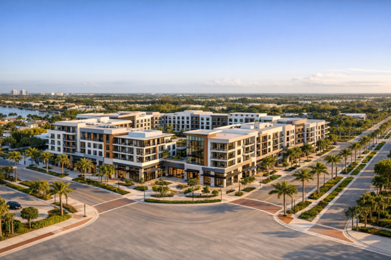
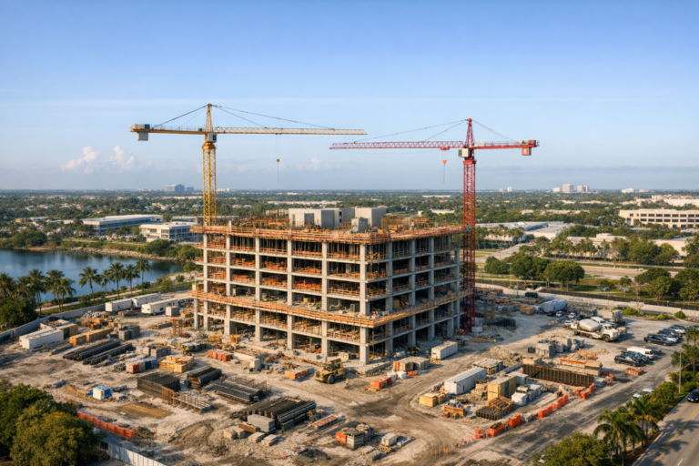
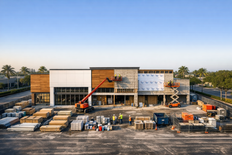
For developers, construction managers, and project stakeholders, clear visual documentation is no longer a nice-to-have. It is part of how modern projects are managed, communicated, marketed, and protected. Ground-level photos still matter, but they cannot show the full site context, logistics, staging areas, roof progress, exterior elevations, or the relationship between the project and surrounding properties.
That is where construction drone photography Fort Lauderdale projects can benefit most. A well-planned aerial photography program gives decision-makers a consistent, high-value view of the jobsite from angles that are impossible to capture from the ground. When handled by an experienced commercial drone operator, these images can support progress reporting, investor updates, internal coordination, marketing, and long-term project records.
This guide explains what developers should know before hiring a drone photography provider in Fort Lauderdale, what deliverables to expect, how to plan recurring flights, and how to evaluate whether a drone company is prepared to work safely and professionally around active construction environments.
Why Developers Use Drone Photography During Construction
Construction drone photography gives developers a visual record of a project as it evolves. Instead of relying only on written updates, phone calls, or isolated site photos, stakeholders can see the relationship between site work, vertical construction, surrounding access roads, laydown areas, parking, landscaping, and nearby structures.
For projects with multiple decision-makers, aerial images reduce ambiguity. A developer can review site progress with investors, lenders, architects, engineers, leasing teams, and ownership groups without requiring everyone to visit the property. This is especially useful in South Florida, where many project stakeholders may be located outside the immediate market.
Professional drone photography can also help teams identify visible changes over time, document major milestones, and maintain an organized project archive. While drone photos are not a substitute for surveys, inspections, or engineering documentation, they are an effective communication tool when used consistently.
What Makes Fort Lauderdale Construction Sites Unique
Fort Lauderdale presents a mix of urban, coastal, and logistical considerations that make professional planning important. Many construction sites are located near dense commercial corridors, residential areas, waterways, marinas, active roads, and controlled airspace. These conditions require more than simply launching a drone and taking pictures.
A qualified drone operator should evaluate the surrounding airspace, nearby airports or heliports, temporary flight restrictions, site access, pedestrian activity, vehicle traffic, cranes, power lines, and construction operations. In parts of Broward County, airspace authorization may be required before a legal commercial drone flight can take place.
Weather is another practical factor. Coastal winds, afternoon thunderstorms, glare, humidity, and fast-moving cloud cover can affect both safety and image quality. Experienced local operators understand how to plan flights around South Florida light and weather conditions, which can make a meaningful difference in the final results.
Common Uses for Construction Drone Photography
Developers often hire drone photographers for several purposes throughout the construction timeline. The best results come from defining the intended use before the first flight, because progress documentation, marketing imagery, stakeholder reporting, and close visual review may require different shot lists.
Progress Documentation
Recurring aerial photos provide a consistent view of construction progress over weeks or months. These images can show site clearing, foundation work, structural progress, roofing, exterior finishes, paving, landscaping, and final completion. When captured from repeatable angles, they become a useful visual timeline of the project.
Stakeholder and Investor Updates
Developers often need to communicate progress to owners, equity partners, lenders, or municipalities. Aerial images can make reports easier to understand and more visually credible. Instead of sending a text-heavy update, project teams can include a set of clear images showing current site conditions.
Marketing and Leasing Support
For commercial real estate developments, aerial construction photos can support pre-leasing, sales presentations, press updates, and website content. Drone imagery can show location advantages, visibility, access points, surrounding growth, and proximity to key roads or neighborhoods.
Internal Coordination
While drone photography does not replace formal project management tools, it can support coordination by showing site constraints and visual context. General contractors and construction managers may use aerial photos to review staging, access, parking, equipment placement, and visible progress between site meetings.
What a Professional Construction Drone Shoot Should Include
A professional construction drone photography assignment should begin with planning. The drone provider should ask about the project location, schedule, site access, desired deliverables, intended use, safety requirements, and any active construction operations that may affect flight timing.
A typical construction drone photography session may include wide establishing shots, straight-down overhead images, oblique angle views from multiple sides, progress comparison angles, surrounding area views, and detail-oriented photos of specific project features. For recurring work, consistency matters. Capturing the same angles from similar positions and altitudes helps teams compare progress more effectively over time.
Developers should also clarify image delivery expectations. Useful deliverables may include high-resolution edited photos, web-ready image files, organized folders by date, labeled views, and a reliable turnaround schedule. If the images will be used for marketing, the final editing style should be clean, accurate, and professional without over-processing the site conditions.
How Often Should Developers Schedule Drone Photography?
The right schedule depends on the project size, pace, reporting requirements, and budget. For many commercial construction projects, monthly drone photography is a practical baseline. It creates a clean record of progress without overwhelming the team with unnecessary images.
For fast-moving projects or high-visibility developments, biweekly flights may be more appropriate. Weekly documentation can be useful for complex sites, major milestones, or projects where remote stakeholders need frequent updates. Some developers also schedule additional flights around key phases such as topping out, exterior completion, major concrete pours, roofing completion, or final delivery.
The most important factor is consistency. A recurring schedule with standardized shot angles is usually more valuable than occasional one-off flights with no visual continuity.
Safety and FAA Compliance Matter on Active Jobsites
Commercial drone operations in the United States must be conducted by a properly certified remote pilot under FAA Part 107 rules. For developers, this matters because construction sites introduce real operational risks: cranes, workers, vehicles, temporary structures, dust, restricted access points, and changing site conditions.
A professional drone company should know how to evaluate airspace, maintain visual line of sight, avoid unsafe operations over people, coordinate with site contacts, and determine whether additional authorizations are required. The operator should also understand that active construction sites are controlled environments where safety protocols, PPE requirements, and communication with the site superintendent may be necessary.
Before hiring a provider, ask whether the pilot is FAA Part 107 certified and whether the company carries appropriate commercial drone insurance. Developers should also provide accurate site details so the operator can plan properly, rather than discovering obstacles or restrictions after arriving on site.
What to Look for When Hiring a Drone Photographer in Fort Lauderdale
Not every drone operator is well suited for construction work. A provider may be able to capture attractive aerial photos but still lack experience with jobsite coordination, recurring documentation, or commercial deliverable standards.
When evaluating a company, look for clear answers to these questions:
- Are they FAA Part 107 certified for commercial drone operations?
- Do they understand construction site safety and coordination?
- Can they plan around controlled airspace in the Fort Lauderdale area?
- Do they offer consistent progress photography from repeatable viewpoints?
- Can they deliver high-resolution and web-ready images in an organized format?
- Do they communicate clearly before, during, and after the flight?
- Do they carry commercial drone insurance?
The right provider should make the process easier for your team, not more complicated. They should be able to discuss shot planning, site access, timing, safety considerations, and deliverables in practical terms.
Preparing Your Site for a Successful Drone Photography Session
A little preparation can significantly improve both safety and image quality. Before the scheduled flight, identify a point of contact who can meet or communicate with the drone pilot. This is often the superintendent, project manager, or site representative.
It is also helpful to share any active work areas, crane activity, restricted zones, parking instructions, gate access details, and preferred photo priorities. If the images are intended for a report or presentation, provide a shot list so the photographer knows which views are most important.
Timing matters as well. Early morning and late afternoon often provide better light than harsh midday sun, especially in South Florida. However, construction operations and safety requirements should always take priority over ideal lighting. A professional operator can help balance visual quality with practical site conditions.
Construction Drone Photography Versus Videography
Photography and videography serve different purposes. Drone photography is usually better for progress records, reports, documentation, presentations, and side-by-side comparisons. Still images are easy to archive, annotate, share, and insert into documents.
Drone videography is better for storytelling, marketing, investor presentations, website content, and project highlight reels. Video can show movement, scale, access, surroundings, and the overall construction environment in a more dynamic way.
Many developers benefit from using both. A monthly package may include a set of progress photos plus a short aerial video clip or edited sequence for marketing and stakeholder communication. The best format depends on how the content will be used.
FAQ: Construction Drone Photography in Fort Lauderdale
Is drone photography legal for construction sites in Fort Lauderdale?
Yes, commercial drone photography is allowed when conducted in compliance with FAA regulations and any applicable airspace requirements. The flight should be performed by an FAA Part 107 certified remote pilot, and some locations may require airspace authorization before the operation.
How much does construction drone photography cost?
Pricing depends on the site location, flight complexity, number of deliverables, editing requirements, recurring schedule, and whether photography, videography, or both are needed. A simple single-site photo session will typically be priced differently from an ongoing monthly documentation program.
Can drones fly over workers on an active construction site?
Drone operations over people are subject to specific FAA rules and limitations. A professional operator should plan flights to avoid unsafe operations over workers and coordinate with the site team to maintain a safe flight area whenever necessary.
How quickly are construction drone photos delivered?
Turnaround times vary by project scope and editing needs. For standard progress photography, many projects can be delivered within a practical business timeframe after the flight. Developers should confirm delivery expectations before scheduling.
Can drone photos replace site inspections?
No. Drone photography is a valuable visual documentation and communication tool, but it does not replace required inspections, engineering reviews, surveys, or code compliance processes. It should be used to support project visibility, not as a substitute for professional inspections.
Final Thoughts for Developers
Construction drone photography is most valuable when it is planned, consistent, safe, and aligned with the way your team communicates. For Fort Lauderdale developers, the right aerial imagery can help document progress, keep stakeholders informed, support marketing, and create a clear visual record from groundbreaking through completion.
Skyview Motions provides FAA Part 107 certified commercial drone photography and videography for construction projects throughout South Florida. If your team needs professional aerial progress documentation for a Fort Lauderdale jobsite, Skyview Motions can help plan the right approach, capture the right views, and deliver polished visual assets that support your project goals.