Construction projects move quickly, but understanding what changed from one week to the next is not always easy. A superintendent may know exactly which slab was poured, which elevation was framed, or which staging area was relocated. An owner, investor, lender, architect, or off-site project executive may not have that same context.
That is where professional drone photography becomes especially valuable. Aerial construction progress updates translate complex jobsite activity into clear visual information. Instead of relying only on written reports, phone calls, and ground-level photos, stakeholders can see the site from a perspective that explains scale, sequencing, access, logistics, and progress at a glance.
For commercial construction teams in South Florida, where projects often involve tight sites, coastal weather, active roadways, and multiple stakeholders, clear visual reporting can reduce confusion and help everyone stay aligned.
Why Construction Progress Can Be Hard to Understand From the Ground
Traditional construction documentation is important, but it has limitations. Ground photos show details well, yet they often lack context. A close-up of rebar, framing, roofing, or site utilities may document the work, but it may not show where that work sits within the entire project.
Written updates can also be difficult for non-technical stakeholders to interpret. Terms that are routine for a construction manager may not mean much to a property owner, investor, or marketing team. Even when the written report is accurate, readers may still ask the same follow-up questions: How much of the site is complete? Which areas are active? Has visible progress been made since the last update? Are access points, staging areas, and exterior improvements moving as planned?
Drone photography helps close that communication gap. It gives teams a visual record that is broad enough to show the full project and detailed enough to support meaningful discussion.
How Aerial Construction Progress Updates Improve Clarity
Aerial construction progress updates are most useful when they are captured consistently and organized around the way project teams actually communicate. The goal is not simply to take attractive photos of a jobsite. The goal is to create visual documentation that answers practical questions.
They Show the Entire Site in One View
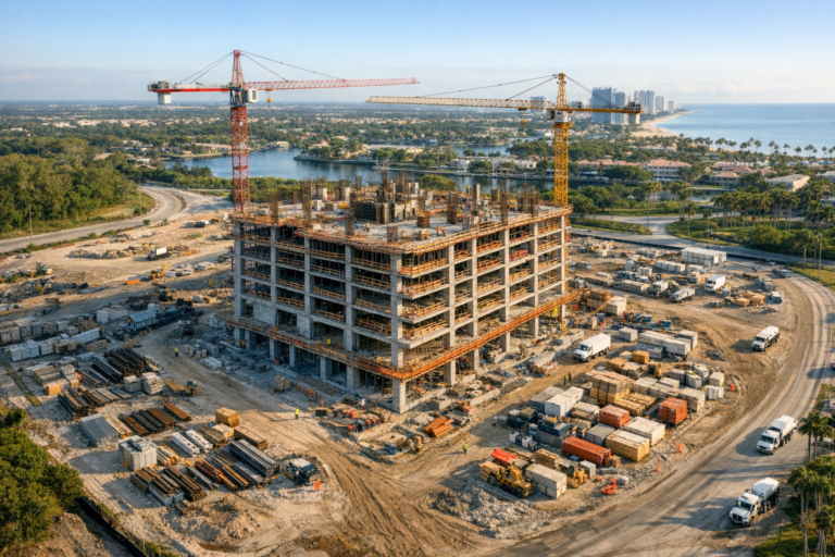
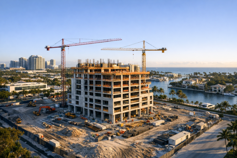
An aerial image can show the building footprint, surrounding roads, parking areas, staging zones, drainage areas, landscaping progress, equipment placement, and adjacent properties in a single frame. This makes it easier for stakeholders to understand how individual tasks relate to the overall project.
For example, a ground photo may show that exterior walls are going up. A drone photo can show which elevations are complete, which sides remain open, where materials are staged, and how the work affects site circulation. That context is difficult to capture from ground level alone.
They Make Before-and-After Comparisons Easier
Construction progress becomes much easier to understand when images are captured from similar angles over time. A drone can document the same site from consistent vantage points each week, month, or project milestone. When those images are reviewed side by side, changes become obvious.
This is helpful for owners and executives who are not on site every day. Rather than reading several paragraphs of explanation, they can quickly see vertical progress, site clearing, foundation work, roof installation, paving, exterior finishes, landscaping, or equipment placement as the project develops.
They Help Non-Technical Stakeholders Follow the Project
Not everyone receiving a construction update has a construction background. Developers, investors, leasing teams, municipal stakeholders, board members, and marketing departments may all need updates for different reasons. Aerial visuals make the information more accessible without oversimplifying the work.
A clear overhead or oblique drone image gives non-technical viewers a reliable reference point. When paired with a concise written update, it can help them understand what has been completed, what is underway, and what is coming next.
What Drone Photography Can Reveal That Ground Photos Often Miss
Drone photography is not a replacement for detailed site inspections, engineering review, or close-range documentation. It is a complementary visual tool. Its strength is in perspective, scale, and consistency.
Professional drone progress photography can help document:
- Overall site development and building layout
- Earthwork, grading, and site preparation progress
- Foundation, slab, and structural progress from above
- Roofing, exterior envelope, and facade progress
- Parking lots, access roads, and circulation patterns
- Material staging and equipment placement
- Relationship between the project and surrounding properties
- Visible progress for stakeholder reports and presentations
This broader context can be especially useful on large commercial sites, multifamily developments, industrial properties, retail centers, schools, hospitality projects, and infrastructure-adjacent construction.
When Drone Updates Are Most Valuable During a Project
The best time to start drone documentation is usually before major work begins. Early aerial images create a baseline record of existing site conditions. From there, each scheduled flight builds a visual timeline of the project.
Pre-Construction and Site Clearing
Before construction activity ramps up, drone photos can document site layout, surrounding conditions, vegetation, access points, and nearby structures. This baseline is useful for internal records and future comparisons.
Foundation and Structural Milestones
As the site moves into excavation, foundations, slabs, and vertical construction, aerial images help stakeholders understand the pace and sequence of major work. This is often when visual updates become especially valuable because the project begins to change dramatically.
Exterior Completion and Site Improvements
Later in the project, drone photography can show roofing progress, facade completion, parking areas, landscaping, hardscape, and final site improvements. These visuals are often useful for owner updates, marketing preparation, lease-up activity, and final project documentation.
How Consistent Drone Documentation Supports Better Communication
Consistency is what separates useful construction documentation from random jobsite photos. A professional drone provider should understand that repeatable angles, timing, image quality, and organized delivery matter.
For progress updates, many teams benefit from establishing a repeat flight plan that includes the same key views each time. These may include a straight-down overhead view, four corner perspectives, street-facing elevations, and wider context shots showing the surrounding area. The exact shot list should be based on the project type, site conditions, and reporting needs.
When images are captured consistently, project teams can use them in owner meetings, internal reports, draw documentation support, marketing updates, and historical records. The visuals become part of the communication system, not just a collection of photos.
What to Look for in a Construction Drone Photography Provider
Construction sites are active, controlled environments. Hiring a drone company for progress updates should involve more than asking whether they can fly a drone and take pictures. The provider should understand safety, airspace requirements, site coordination, image planning, and professional communication.
Before hiring a provider, consider whether they can:
- Operate under FAA Part 107 commercial drone requirements
- Coordinate with site contacts before arriving
- Respect active work zones, equipment, crews, and site safety rules
- Plan repeatable aerial perspectives for long-term documentation
- Capture both wide context images and useful detail views
- Deliver organized files in a format your team can easily use
- Communicate clearly about weather, access, timing, and limitations
In South Florida, weather and airspace planning can also affect scheduling. Wind, rain, temporary restrictions, nearby airports, and site-specific safety concerns may require coordination. A professional provider should set realistic expectations rather than force a flight when conditions are not appropriate.
Practical Ways to Use Drone Progress Images
Drone images can serve many departments beyond the field team. The same set of progress visuals can be adapted for different business needs when captured thoughtfully.
Common uses include:
- Monthly owner reports
- Executive updates and investor presentations
- Construction meeting visuals
- Developer and lender communication
- Marketing previews for commercial real estate projects
- Website and social media project updates
- Historical project documentation
- Coordination with architects, engineers, and consultants
For example, a general contractor may use aerial imagery to explain logistics during a project meeting, while a developer may use selected images to show leasing prospects that a commercial property is progressing. The value comes from capturing visuals that are accurate, current, and easy to understand.
Drone Photography vs. Drone Video for Construction Updates
Photography and video each play a different role in construction communication. Still photos are often best for documentation, reporting, side-by-side comparisons, and quick review. They are easy to insert into reports, annotate during meetings, or archive by date.
Drone video is useful when motion adds value. A smooth flyover can show the relationship between access roads, completed areas, active work zones, and surrounding neighborhoods. Video can also be helpful for presentations, marketing, and project recap content.
Many construction teams benefit from using both. Photos provide the documentation backbone, while short video clips help tell the broader project story.
Important Limits to Understand
Drone photography is powerful, but it should be used appropriately. Aerial images do not replace professional inspections, survey work, engineering verification, or on-site quality control. They also cannot show every concealed condition or detail that would require close physical review.
The strongest results come when drone updates are integrated into a broader documentation process. They should support project communication, improve visual understanding, and create a reliable record, while the project team continues to rely on qualified professionals for technical evaluations and compliance-related decisions.
Frequently Asked Questions
How often should a construction site be photographed by drone?
The right schedule depends on the project. Weekly updates may be useful for fast-moving construction, while monthly flights may be enough for longer projects with slower visible changes. Many teams also schedule flights around major milestones such as site clearing, foundation completion, topping out, roofing, paving, and final exterior work.
Are drone progress photos useful for small construction projects?
Yes, if the project has stakeholders who need visual updates or if site context matters. Even smaller commercial properties can benefit from aerial views that show layout, access, exterior progress, parking, and surrounding conditions.
Can drone photos be used in owner reports?
Yes. Drone photos are often well suited for owner reports because they communicate progress quickly and clearly. They work best when images are dated, organized, and captured from consistent angles over time.
Is drone photography safe on an active construction site?
It can be conducted safely when handled by a qualified commercial drone operator who coordinates with the site team, follows applicable FAA requirements, respects site safety protocols, and avoids unnecessary flight over people or active hazards. Planning and communication are essential.
Do drone updates replace written construction reports?
No. Drone updates are most effective when paired with written reporting. The photos provide visual context, while the written report explains schedule details, technical progress, decisions, and next steps.
Clearer Construction Updates Start With Better Visual Context
Drone photography can make construction updates easier to understand because it shows progress in a way that written reports and ground photos often cannot. It gives stakeholders a clear view of the whole site, helps teams compare progress over time, and makes complex jobsite activity easier to explain.
For owners, developers, general contractors, construction managers, and commercial real estate professionals, aerial construction progress updates can improve communication and create a stronger visual record from start to finish.
Skyview Motions provides professional commercial drone photography and videography for construction projects throughout South Florida. If your team needs clear, consistent, and professionally captured progress visuals, Skyview Motions can help document your project with the perspective and reliability your stakeholders expect.